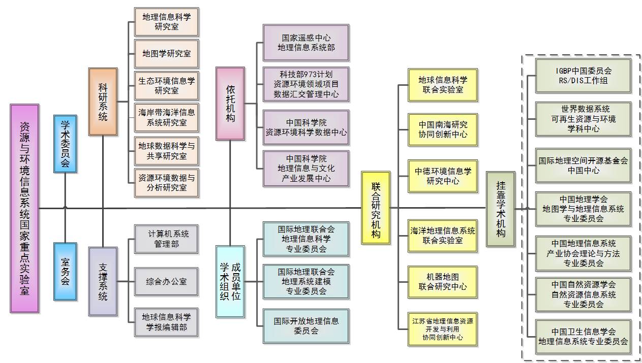
The scientific research system (six research departments):
1. Research department of geographic information science: mainly carries out researches on spatiotemporal data analysis and modeling, surface process pattern mining and knowledge discovery.
2. Research department of cartography: mainly develops theories, methods and technical systems of modern cartography to provide visual application services for resources, environment and related fields.
3. Research department of eco-environmental informatics: mainly develops satellite-ground integrated high-precision surface modeling methods and theoretical system of eco-environmental informatics.
4. Research department of coastal and marine information system: mainly conducts researches on the theory and methods of marine spatiotemporal and multidimensional modeling, comprehensive analysis, expression and integration.
5. Research department of earth data science and sharing: mainly researches into the theories, methods, and technologies of earth data science and geoscience data sharing and informatization, as well as builds and operates the national data sharing infrastructure of earth system science.
6. Research department of resources and environmental data analysis: mainly carries out the generation, processing and application of resources and environmental data, and constructs regional, national, peripheral and global long-term spatial data sets of resources and environment.
Partners:
National and CAS research centers:
Department of geographic information system of the national remote sensing center;
Data exchange management center of resources and environment of the national 973 programs, the ministry of science and technology, China;
Data center of resources and environmental sciences, CAS;
Geographic information and cultural industry development center, CAS.
Domestic and international academic organizations:
RS/DIS working group of the Chinese National Committee for the International Geophere-Biosphere Programme (CNC-IGBP);
World Data System for Rrenewable resources and environment;
Open Source Geospatial Foundation-China Chapter;
Professional Committee of Cartography and Geographic Information System, the Geographical Society of China;
Professional Committee of Theory and Methods, China Association for Geospatial Information Society;
Professional Committee of Natural Resources Information System, China Society of Natural Resources;
Professional Committee of Geographic Information System, Chinese Health Information Association;
Member units of international academic organizations:
Professional Committee of Geographic Information Science, International Geographical Union;
Professional Committee of Geographic System Modeling, International Geographical Union;
International Open geographic information committee.
Joint research institutions:
Joint Laboratory of Earth Information Science with Chinese University of Hong Kong, etc;
Joint Laboratory of Marine Geographic Information System with the Institute of Oceanology, CAS;
Joint Research Centre of Machine Map with the PLA Information Engineering University;
Sino-German Research Center for Environmental Informatics with the Helmholtz Association of German Research Centres;
Collaborative Innovation Center of South China Sea Studies with Nanjing university, etc;
Collaborative Innovation Center of Geographic Information Resources Development and Utilization, Jiangsu Province, with Nanjing Normal University.